Thank you to Lori Waters for the following guest environmental law alert post.
One Sunday morning, I received an intriguing link to the “Route Safety” animation videos for the proposed Enbridge Northern Gateway pipeline. As one of many British Columbians opposed to the pipeline and to any lifting of the tanker ban along our coast, I watched Enbridge’s animations with interest.
 I work as a scientific illustrator and animator, and have produced geographical and bathymetric animations. To create animations such as the Enbridge animation, the animator finds an appropriate geographical dataset, and uses it to create a 3D model, which can then be coloured or animated to create the desired narrative. Accurate datasets used to create models for geographical animations are readily available from government websites. Datasets created via methodical scientific processes by government scientists do not omit large geographical features (such as islands), unlike the 3D model Enbridge created for their public “route safety” animation.
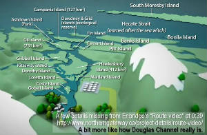
People familiar with the BC coast – particularly anyone who has kayaked it – will know that our coastline is torturously convoluted and replete with plentiful islands and islets. Enbridge’s portrayal of the channel was so obviously wrong that I felt it was very important to try to make others aware of the disinformation on Enbridge’s website. I set about to create a series of images to demonstrate that Enbridge had begun with an accurate dataset, but that they had manipulated the data to remove all of the islands from Douglas Channel, and I estimated the quantity of land mass area that Enbridge had removed, so that people could readily understand the implications of the removal of those land masses from the animations. By creating overlays from Google Earth, I was able to show that the majority of the coastline in Enbridge’s model was accurate – Enbridge simply removed all of the islands from Douglas Channel, leaving the rest of the coastline and only a couple of islands at the mouth of the channel intact.
 In my view, the removal of the islands by Enbridge was particularly important because the animations were presented on Enbridge’s primary website where members of the public could be expected to go for information on the proposed project, and because the majority of visitors to the site would likely have the expectation that the information that Enbridge was presenting on the site would be correct information. However, it was clear from Enbridge’s videos and their disclaimers that instead, grossly inaccurate information was being presented to the public on the primary website which purported to provide project information. And, as shown by the images that I created, in order to create their animation, Enbridge would have had to deliberately and grossly manipulate the geographical model used in order to render Douglas Channel as essentially devoid of islands.
Furthermore, after the images I created went viral, it was pointed out that Enbridge also eliminated the islands on another graphic showing a sillouette of a map of British Columbia. These images - especially when comparted with Canadian Hydrographic Service’s Marine Charts - made it clear that information had been deliberately manipulated, not only in the animations, but also in simple 2D informational graphics. Enbridge later moved the graphic's title to centre on Douglas Channel, making the 2D map data manipulation no longer visible.
 The images I created received a lot of media attention. Some of the most interesting media pickup included legal discussions of misrepresentation in advertising, and discussions of data manipulation in GIS users groups - including mention of Mark Monmonier’s book entitled “How to Lie with Maps.”
I felt that Enbridge needed to account for these misleading videos and I asked West Coast Environmental Law whether there was any action that could be taken to take Enbridge to task. West Coast Environmental Law helped me craft complaints to the Advertising Standards Council (an industry association which governs advertising in Canada) and the Competition Bureau of Canada.
Although the Ads Council has said that they won't look at the Complaint while it's with a Federal Agency, and the Competition Bureau wrote to me today (September 14th, 2012) to advise that I won't be advised of the status of their investigation results, I remain hopeful that Enbridge will be held to account for this data manipulation. I think all Canadians – especially British Columbians - have the right to make their decisions based on accurate information. Ironically, Enbridge’s response once my images went viral, was to say that activists were misleading the public.
By Lori Waters, scientific illustrator and animator.
Graphics courtesy of Lori Waters. Note: The views of guest authors do not necessarily reflect the views of West Coast Environmental Law.
Sign the Sum of Us Petition - based on Lori's work - asking Enbridge to stop misleading the public about the risks of an oil tanker spill.